The Historic Sunset Highway |
|
|
☰ Main Menu |
|
|
Ellensburg to Spokane via Vantage Ellensburg to
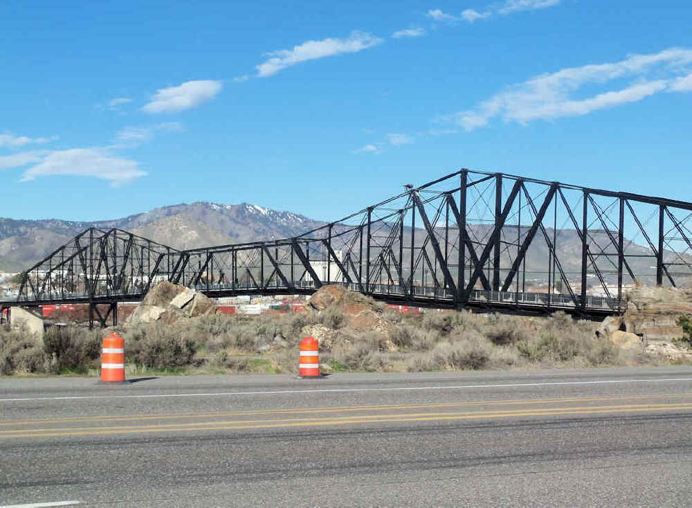
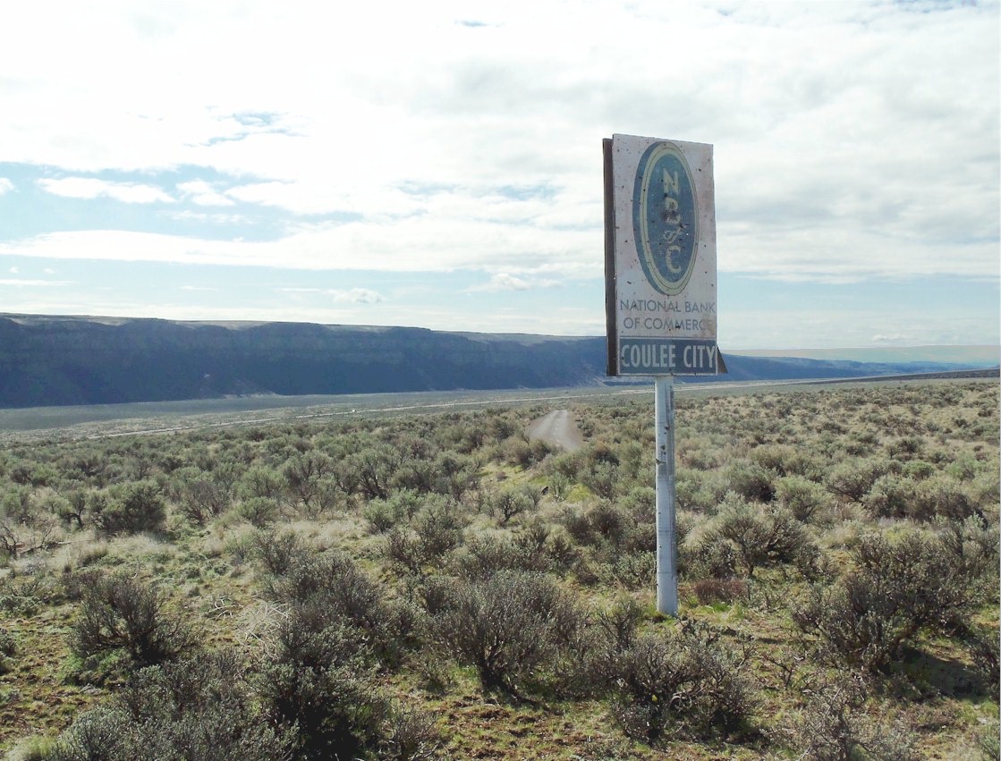
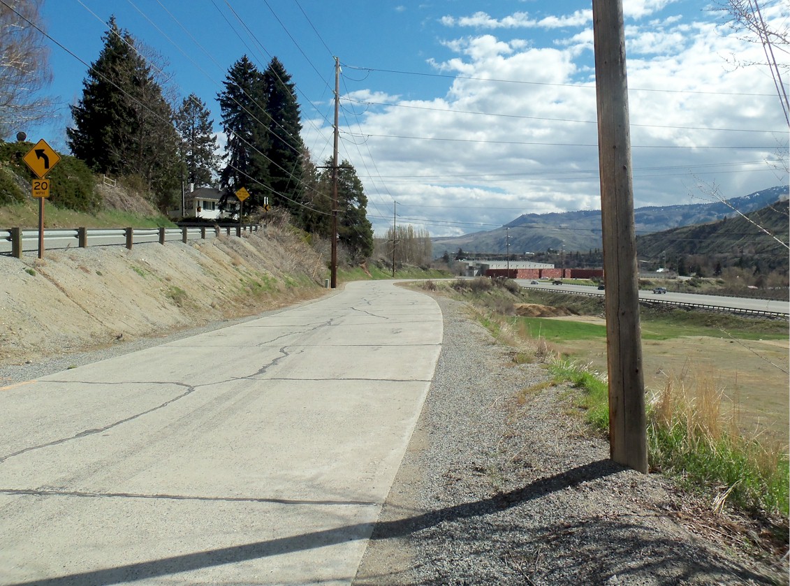
Spokane On the way to Ellensburg We left at 6:00am to start our journey. The rain wasn’t pouring as hard as it has been for awhile, which was unusual. We packed up the car and headed toward Snoqualmie Pass. We decided to take the old route over the pass and look for the Yellowstone Trail marker but the snow blocked our way so we had to go back to the interstate. From Ellensburg to Quincy then on to Wenatchee Before Blewett Pass became a viable route from Cle Elum to Wenatchee travelers took this route. In the early days of the Sunset Highway, travelers went east to Vantage and across the Columbia River on the Vantage ferry. Then it was north to Quincy then west to Trinidad. The traveler followed the river up to the town of Columbia River. The town was about 2 miles south of the Rock Island Dam. This town is long gone today. If you were heading west to Wenatchee in those days you would have crossed the river just south of the old town, then go up the hill and turn right onto the old Colockum Road and continue north as this road turns into the Malaga-Alcoa Hwy into Wenatchee. Since the ferry is no longer there we had to take Hwy 28 north along the east side of the river into Wenatchee. If you turned left after reaching the Colockum Rd it will take you over the Colockum Pass back to Ellensburg. The Road over Colockum Pass was a rough road back in the late 1800's when it was built and it is a very rough road today. It is still passable but you need a 4 wheel drive. Below is an article from the Spokane Review July 27, 1915 by Frank W. Guilbert (Frank is the Secretary of the NPH Assoc. and is talking as travelers were going east. Our trip was west) “We are advising people who wish to go to Wenatchee to double back re-crossing the Columbia River at Columbia River crossing near the mouth of Colockum creek, thence, southerly to the crossing above Beverly known as Vantage terry, thence westerly through Ellensburg and Cle Elum to Seattle.” Obviously the Colockum road was out of the question due to the roughness. Old Road to Wenatchee from the town Columbia River Before Hwy 28 was built, there was no way a traveler could pass along the east side of the river to Wenatchee from the town of Columbia River to Rock Island due to the steep hillside. There was just enough room for the Great Northern mainline from Seattle to Spokane to pass through. There is an old route travelers may have took instead of taking the ferry. This old road shows up on the 1915 map that shows it went to Wenatchee from Columbia City on the east side of the river on the hill top and is still viewable from the Google satellite. This road began at a point between the town of Columbia River and Appledale, it was called Moses Coulee. these towns are both long gone today. If you were going North on Hwy 28, you would take a right onto Palisades Rd and drive northwest for about a mile heading up the Moses Coulee. This road follows the old Mansfield Line of the Great Northern. I am not sure why this road was not preferred by the Sunset Hwy and NPH instead of the ferry. My guess it was because of the hills involved. Here is a link to the map of this old road. I just used place marks so you can see the road in satellite mode. It is very visible still and from what I see not used anymore until it reaches Farley Rd Sw. From Wenatchee to Waterville After these travelers reached Wenatchee, they would cross over the Columbia again at the Old Wenatchee Bridge built in 1908 and still stands today. Pedestrians use the bridge now. At Orondo, we turned to go up Corbaley Canyon toward Waterville. Going up the canyon, we turned onto Badger Mountain rd. This is the old route up the hill. The road is good all the way up past the second switchback then it is blocked. The rocks falling from the cliffs have made the road impassable from there. We turned around, went back to the new road, and continued into Waterville At the top of the hill there was an old abandoned farmhouse and a old time billboard painted on a barn. We got to Waterville and took some photos of the Old Waterville Hotel. The hotel was built in 1903 and I am sure it served many tourists travelling along the YT and NPH. They are opening the rooms for business on April 19, 2013 for the season. It is great to see the old hotel still in business. There is an old wagon road that went up the canyon south of the old route to Waterville. This route shows up on the 1915 maps. I do not know much about this route. You can see the route on the map link above. From Waterville to the Moses Coulee We headed out of town and headed for the Moses Coulee and the old lost town of Spencer. From Waterville we took the early route on 2 rd NW east just to Golf Rd then headed south to Douglas. The old route continued on eastward past Farmer. The 1920's route went from Waterville to Douglas along the current US 2. After taking a photo of the old church in Douglas, we headed up the hill where we spotted an old alignment rounding the curve. After stopping for some photos, then it was due east to the Coulee. Just before the drop into the Coulee you turn left onto S. Division rd go north and turn right onto Baseline Rd E. This is the old road heading into the coulee. There was a sign that said “dead end” but we didn’t care and decided to go as far as we could. On the first right curve heading down we stopped for some nice photos of the coulee. I knew this is about where the old wagon trail and 1915 alignment spilt off from this road and headed down. I wanted to see if we could find it but it is on private property so we were not able to do so. I was able to spot it in the distance and grab a photo of the wagon trail. While standing there taking photos I noticed that the curve was realigned. I could see the original curve to the left. It was interesting to see that they realigned the curved sometime over 40 years ago. I have a map from 1965 that shows they were still using this route into the coulee. We continued down into the coulee. The road was not too bad for an abandoned road. We could begin to spot the old telephone poles heading from Wenatchee to Coulee City. The poles many that are still standing with insulators still attached are 100 years old. We followed the road around the switchbacks. At the last corner before the bottom we saw the old bank billboard sign next to a rusty old hollowed out 1930’s sedan. It is cool to see this old billboard still advertising the old National Bank of Commerce. I did a search and found out this bank started in 1889 and lasted until 1969 when Rainier Bank bought it up. In 1987, Security Pacific Corp bought Rainier bank and then in 1992 this bank merged with Bank of America. The regulators did not want B of A to be too big so it broke off and now the old National Bank of Commerce today is Key Bank. As we approached the bottom of the coulee, the pavement ended. I could see on the old maps that this is about where the pavement ended and gravel and dirt begin. From the satellite you can see the road going around the bend and heading north to where Spencer used to be. From the ground, I could not spot the old road. From the point where the pavement ends, a dirt road heads south and connects to US Hwy 2. Even though the sign at the beginning said it was a dead end, we managed to continue on our journey without going back. We passed by the old town of Spencer and wondered where it could have been. There is no trace of anything except the old alignment heading toward the east side of the coulee and toward Sulphur Springs. I learned of this old town from reading the forum. We turned left onto Jamison Lake Rd NE and stopped at the bottom of the east side of the coulee to see if we could determine how the 1915 travelers climbed up the hill. On the old 1915 map, the road shows that it climbed up this hill and followed the telephone poles. I spotted a dirt road heading up the hill next to two poles still standing near the top of the hill. From looking at the terrain, it seems logical that this is about where they climbed up. I walked up the road and took some photos of the coulee. I could see what appears to be a faint path of an ancient road next to the existing dirt road. I am certain that this had to be where the first route of the YT and NPH lay. From Moses Coulee to Coulee City The old hwy road now called Sulphur Springs Road NE can be reached by this dirt road. There were no fences and no "no trespassing" signs so I imagine if you had a 4 wheel drive vehicle you could drive up to the old pavement and follow it up and around the switchback. You can’t take this old road far because at Sulphur Springs there is a gate. So somewhere, it becomes private property. We got back in the car and headed toward Coulee City. About 3 or 4 miles east of the coulee we turned left onto H rd NE and travelled north to 1st rd NE. From the map of 1915 it shows the old route coming from the coulee going east onto 1st rd NE. You can see the telephone poles again and looking west beyond the gate I could see the old county road coming around the hill. The original highway is on the hillside to the left. From looking at the old 1915 map it appears that the old trail continued east on 1st rd NE then turned right onto J rd NE continued south to Baseline rd. The old route follows Baseline rd east as it turns left and meets back up with the current US hwy 2 and then east into Coulee City. On the way to Coulee City I grabbed a photo of a old abandoned schoolhouse near J St NE and a section of the old alignment while going down the hill. When we got to Coulee City we decided to take a detour to Dry Falls. After we visited the falls we drove back to Coulee City and found an old abandoned Motel. We left town and headed east on the 1918 route which is now called Rd 36 NE to R rd NE and then turned left and travelled North to Hartline. Both of these roads are newer asphalt. As we we travelling along Rd 36 we spotted an abandoned barn and got a cool photo. History of Dry Falls In the heart of the Grand Coulee lies one of the natural wonders of North America, the Dry Falls cataract. This 3.5-mile-wide chasm of basalt, with a drop of 400 feet, was left high and dry thousands of years ago as the last of several Ice Age floods swept through the Grand Coulee. History of Banks Lake Banks Lake was referred as the Equalizing reservoir back when Coulee Dam was built in the late 1930's. It has submerged the old routes at Coulee City. This reservoir is part of the Columbia Basin project and is used to irrigate the Columbia Basin. From Coulee City to Wilbur When we got to Hartline we decided to go into town to see if the old Hartline Motor Supply was still there and sure enough it still is there just like the photo that Dave has posted on the forum. From there it was back onto US 2 toward Almira. We followed the 1918 route into Almira, found it all good pavement, and still in use. Almira got its name from the first settler in the 1880’s Charles C. Davis who purchased land and erected a small store to serve the few settlers living in the area. He named the place Almira after his wife’s given name. His farm had previously been called "Davisine". The Almira Hotel was built in the early 1900’s and had caught fire first in 1903. In 1917, it caught fire again and they had to rebuilt it. The current hotel you see today is from this 1917 rebuild. This local landmark is on the National Register of Historic places. When we got to Almira, we stopped in at the Hotel and had lunch. The new owners are fixing the historic hotel so guests can stay there for the night someday. There is a restaurant inside called Charlie’s Restaurant and Lounge. We talked to the owners for a bit and after our meal, we took some photos of the old lobby and the old radiator, then headed out of town. We took the old 1915 route out of town, which is just north of the hotel and just across the railroad tracks. We travelled east back over the tracks and connected to the old alignment. The road is abandoned but is still passable. The old asphalt is broken up most of the way and resembles a gravel road. It continues along side of the tracks to Corbitt Draw rd. From the 1915 map it shows an older alignment that veered right over the tracks curved right and crossed Corbitt Draw rd and continued to curve right back over the track and connected back to the old road. At Corbitt Draw rd you have to turn right and head south on this dirt road to US 2 as the old road on the east side of Corbitt Draw rd is impassable. Back on US 2 and heading east, we turned right onto the old route. This is now called Bruce Rd and Anderson Rd. E. This is good newer pavement and still in use. This takes you into Govan and you pass through looking at the old abandoned houses and the old abandoned schoolhouse across the field. You get a surreal feeling thinking about what was it like when this place was new and people going about their business and the children playing in the schoolyard. After Govan we travelled north up Govan Rd N across US 2 then right onto Bandy rd. This is the old route and is decent pavement and still in use. Bandy rd connects back to US 2 and east toward Wilbur. If you continue due east on US 2. The old route continues due east while US 2 veers to the left. Wilbur Airport rd is the old route into Wilbur. Wilbur Airport rd is dirt and it does not go through into town anymore. You have to turn left and head north back to the new hwy. There is an alignment from 1918 that before you turn left it veered off to the left across US 2 then curved right and connected to what is now called Golf Rd. You can’t follow this old alignment until you get to Golf Rdwhich takes you east into town. From Wilbur to Davenport We headed through Wilbur and back onto US 2. Here is a photo of what appears to be an old gas station now a winery in Wilbur. After Wilbur the route continued straight onto Lartzen Rd. The old route stayed due east on this dirt road into Creston. There is a 1918 alignment that is now called Hills rd that veers left, curves right just before the new hwy and follows the new hwy just to the right as you drive east and continue into town. There is little trace of this old alignment. It is visible from the satellite. We came into Creston and followed US 2 through town. Creston gets its name as it is the crest of the hill and the highest point in Lincoln County. As you leave Creston, the old route veered right onto Chip Dump rd. This road is dirt as it heads south to the tracks veers left and heads east back to US 2. Just before this road connects to US 2 in the late 1800’s there is a old wagon road to Davenport. It turned right and crossed the tracks and continued south pass Ice Lake and connects to the Old Hwyabout where the new hwy veers away from the tracks. It shows up on the 1911 map. It is visible from the satellite. The old road splits away from US 2 at the bend just pass where Chip dump rd connects back to US 2. This road is now on private property and is now gated. About a mile and a half, pass the bend you can turn right onto the old hwy and follow it about a mile. The pavement is decent and you can see the cuts and fills in the roadbed. You will have to turn back to continue on to Davenport At the rest stop on US 2 near the tracks there used to be a railroad station called Fellows. The maps call the place Telford. If you walk up the hill behind the rest stop you can see to old hwy as it follows next to the tracks to meet up to US 2. The old wagon road crosses the rest stop but I can’t find any trace of it. The old wagon road I believe is the original 1915 -1918 route of the YT. You can see this road from the satellite but it is gated so we couldn’t drive down it. I believe this old road connected to Sterett Rd and headed due east to 7 mile rd. Then it turned left travelled north to Cottonwood Creek Rd and then east to gunning rd south to US 2 and then east into Davenport. Along Cottonwood Creek Rd we found this steel truss bridge. I found on the 1943 Lincoln Co map that the old road crossed the creek where this bridge is. It seems strange to see a steel bridge in the middle of nothing. The old Bluestem line of the Great Northern also passed through this gully on the way to Peach, WA an old town submerged by Lake Roosevelt. The tracks were never laid but they did finish the grade. I believe this is the original route because of the 1911 map and the terrain makes this the only feasible way through the gully. It is my theory and will need more research to prove this was the original route. In Davenport, we stopped and took photos of the old courthouse. Then travelled east on Sinclair St. to the old Sunset Hwy. This part of the old Sunset hwy is good asphalt and is still in use. A few miles up the Old Sunset Hwy, the road turns into original concrete pavement. The concrete is still in good shape as we headed to Reardan. From Davenport to Spokane Just before Reardan, the old hwy crosses the new hwy and then curves right back to the new hwy into town. This part of the old road is concrete but is in bad shape. It is passable but much of the concrete has crumbled. As you leave Reardan, the old road veers right onto Brommer road. This section of the old hwy is concrete and in good shape. You continue down Brommer and then turn east onto Anderson rd. it remains concrete but is in poor shape. Right before you connect back to the new hwy, you turn right on a gravel turn and then back onto the old concrete road. This part of the hwy is in poor shape but drivable. You then turn left and drive east toward Spokane. This stretch of pavement we found the date stamp in the concrete. This part of the road is a single slab and in poor shape. You then connect back to the new hwy and go east to Deep Creek where the old hwy turns left and heads up the hill. This part is old concrete and in very good shape. It is a private road but you can drive through. Then it is all new hwy along the old route into Spokane. The 1913 concrete bridge over the Spokane River is still in use. The next day it is back home to Seattle. Spokane to Cashmere We followed the newer hwy to Davenport and just past the road to Rocklyn you can drive on the old alignment that makes the curve along with the railroad tracks. This pavement is very old asphalt and in rough shape but drivable. This old alignment connects back to US 2 and then we traveled on the new road to Wenatchee. In Wenatchee, we took the old 1920’s route on Easy St. toward Monitor. Crossed the 1931 bridge into Monitor and followed the old Monitor road north to the old 1907 bridge over the Wenatchee River. The Old Monitor Road continues west to Cashmere. There is an older alignment now called Casey’s Corner. I found a date stamp from 1920. this concrete is in great shape. The older road crossed the new hwy and is now called Eels Rd. From Eels Rd the route crosses the river on Cottage Ave into Cashmere. The old hwy follows the river on the south side all the way to Dryden where connects up with the new hwy. The old road crossed the new hwy and becomes what is now Main St. We found 6 date stamps along this stretch of old concrete. The dates were from July and August of 1926. The concrete is in great shape. The old road continues on Main St. and then veers left onto School Rd. this is all good concrete and then it connects back to the new hwy then over the river. There is no access to the new hwy from school rd and you will have to drive back around. The Early road then turned right onto what is now Sanders Rd, continues North over a nice old 1910’s concrete bridge then turns left, and heads toward Hwy 97 and Blewett pass. We wanted to drive up the old Blewett pass hwy but it is closed. They are building a new bridge at the North end of the old hwy so you cannot use this road until the bridge is completed. Driving up the new Blewett Pass Hwy you can spot the old alignment along side the new road. At the old town site of Blewett I took a photo of the old alignment. This region had many miners looking for gold. The old Town of Blewett was a mining town. The town of Liberty was also a mining town. The town of Liberty originally was on the Old YT and NPH. The old town of Liberty is about were you turn onto the Liberty Rd off the Blewett Pass rd. The place were Liberty is today was called Meaghersville. I do not know why they changed the name. From there we traveled to I-90 and back over the pass back home. |
|
 |
|
 ©2014 - 2017 sunset-hwy.com All Rights Reserved |
|