The Historic Sunset Highway
in Washington
The Old Blewett Pass Wagon
Road
The Historic Sunset Highway
in Washington
The Old Blewett Pass Wagon
Road
The Old Blewett Pass Wagon Road
Most people are familiar with the Old Blewett Pass Highway , built in 1922 with it’s 248 curves on a narrow 13 mile stretch of highway. The stretch of road that became a part of the Yellowstone Trail in 1925. Well before that old highway was built, there was an earlier road over Blewett Pass.
In the early days, there was an Indian Trail over Blewett Pass that was used by people who were traveling north and south between the Columbia River and British Columbia. They used this trail over the past hundreds of years or longer.
In 1858 gold was discovered on the Thompson and Frazier Rivers in Canada . The miners who went in search of this gold started from Seattle and took the Cedar River Trail from Renton and followed the Cedar River to Yakima Pass and then down into Cle Elum.
Miners coming from The Dalles on the Columbia River, took the old Military Road from Rockland that was on the opposite side of the river from The Dalles. This road ran north to Fort Simcoe and then it was by pack trail to Cle Elum. This is where these trails merged and continued north to Canada. This northern route from Cle Elum would eventually become the route of U. S. Highway 97.
In 1861 a group of prospectors were on their way to the gold region and as they were passing by Ingalls Creek near Wenatchee , they stopped to pan gold. Sure enough they struck pay dirt. They quickly made camp and decided to stay there and not to continue on to Canada.
Sheriff Russell, who was running mail between Seattle and the Canadian mines, was also carrying word that Lincoln was elected president to the American miners who were there. As he was passing by Ingalls Creek he encountered the pack train and the miners. After hearing and seeing what they had found in the creek, the Sheriff resigned his post. Kellogg was sent back with the mules to Seattle for more supplies.
The sheriff gave Kellogg his letter of resignation saying he was making good enough money and urged his friends to get on up here. He also sent the mail ahead to Canada with his brother while he stayed to pan for gold. When word got back to Seattle it started a rush to Wenatchee . Seattle was cleaned out of all available supplies and every mule and horse was taken as pack animals. Yesler’s Mill in Seattle had to shut down because the lead sawyer and foreman took off for Wenatchee gold.
Ingalls Creek is located on the north end of Blewett Pass. The boom town of Blewett sprang up 3 miles south of Ingalls Creek and was known as the most violent town in the region. In 1891 the miners at Blewett, volunteered some time each month and a wagon road was eventually built from Cle Elum north to Blewett. This wagon road was crude and had steep grades. The people of Seattle were calling for a road to be built between Seattle and Wenatchee for the miners.
The merchants wanted to have this road so the migration of gold seekers would purchase their supplies in Seattle instead of The Dalles . This wagon road was finally completed to Wenatchee and then to Spokane and was designated State Highway No. 7 in 1908, the precursor to the Sunset Highway.
This is the road that had the 30% grades and where all the stories about cars having to attach logs to the rear to help slow it down while going over the hill. There is another story were the daughters jumped out and dad rode the car down the hill the rest of the way when the brakes failed. Everyone came out ok. This hill is located on the southern side of the pass. The switchbacks of 1922 eliminated this steep hill.
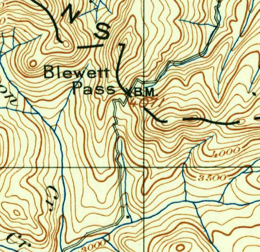
The grade was in the area of 20% to 30%. Once you reached the summit the road going north continued down the Peshastin Creek Gulch and followed the creek bed to where it meets Scotty Creek . At Scotty Creek the old wagon road follows National Forest Road No. 7324 to where it meets the 1922 road.
In 1919 the Old State Highway No. 7 became a section of the Sunset Highway. In 1922 the old road along Peshastin Creek and the steep hill over Blewett Pass was bypassed by the new-old road, along with it’s hundreds of curves, switchbacks and Echo Point.
This summer my wife and I took a trip to Blewett Pass to see this hill. We were able to drive on the old dirt highway for about a half a mile after it left the 1922 road. Just before this road ends at the clearing, the old wagon road veers to the left and continues up the hill. It is faint and hard to see. I was able to walk to a point just below the infamous hill climb. There was so much brush it had completely blocked the way. We were so tired from all the walking in the 100 degree heat that we forgot to drive to the top and look down. Oh well next year.
So is the Old 1922 Blewett Pass Highway actually the New Blewett Pass Highway ? In 1954 the 1922 road over Blewett Pass was bypassed with a new road over Swauk Pass. The name never really caught on and people just called it Blewett Pass anyway. The highway department renamed Swauk Pass to Blewett Pass in the 1960’s and the 1922 Blewett Pass Highway became the Old Blewett Pass. So should the 1891-1921 road over Blewett Pass be called the “Really Old Blewett Pass.
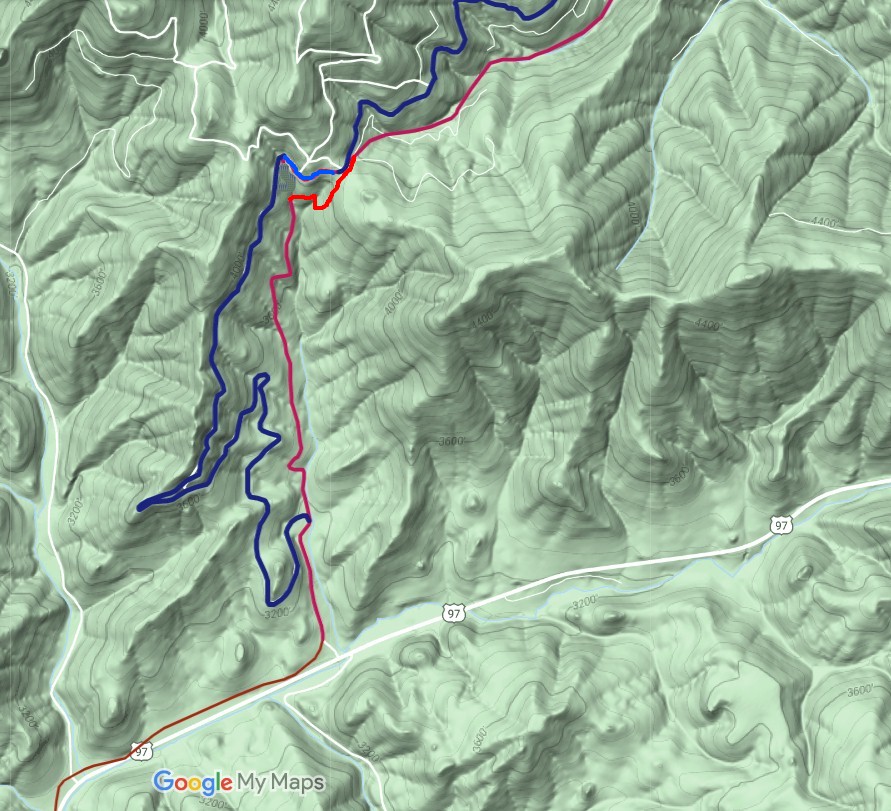
Map showing the 1922 Sunset Highway (blue line) and the 1891 Wagon Road (red line). this is the southern end of the pass. 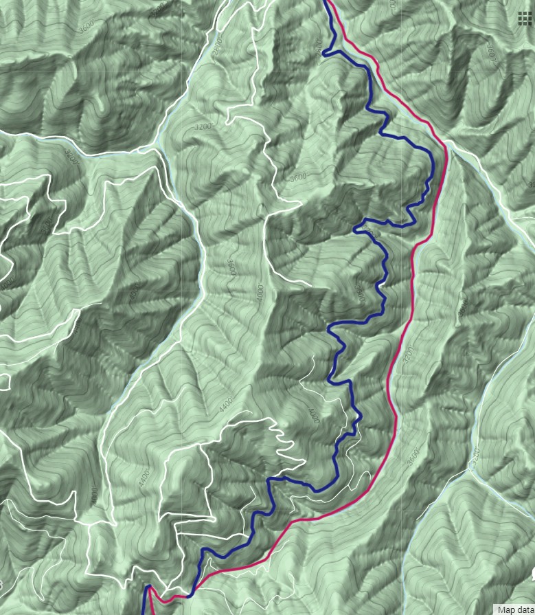
North end of Blewett Pass. The wagon road built in 1891 became the State Road No. 7 in 1908 and then the Sunset Highway in 1919. 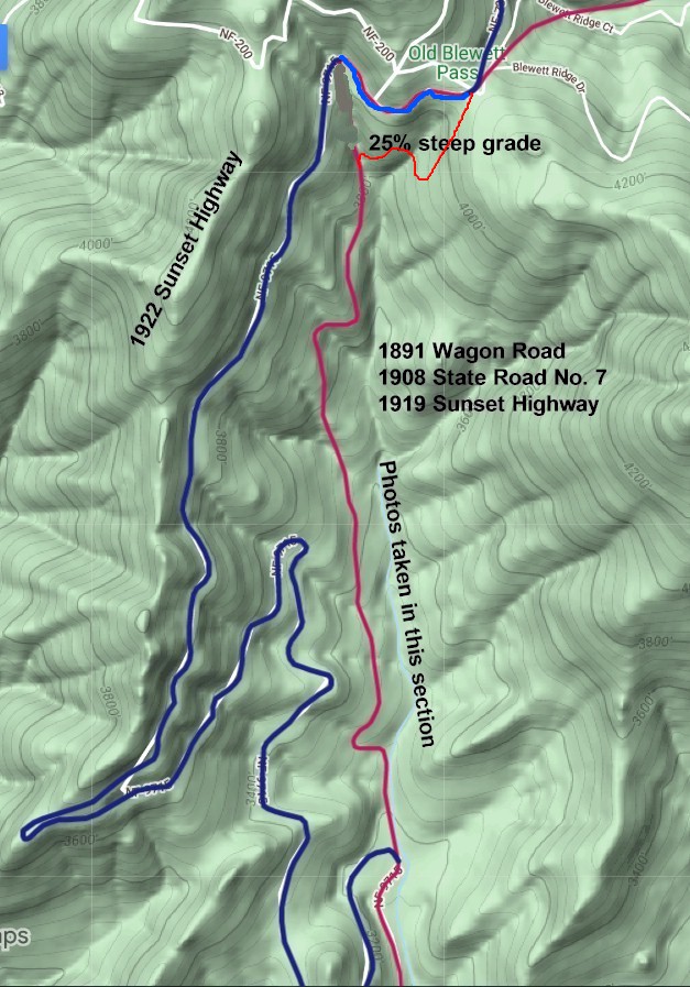
Map showing location of photos and the 25% steep grade. 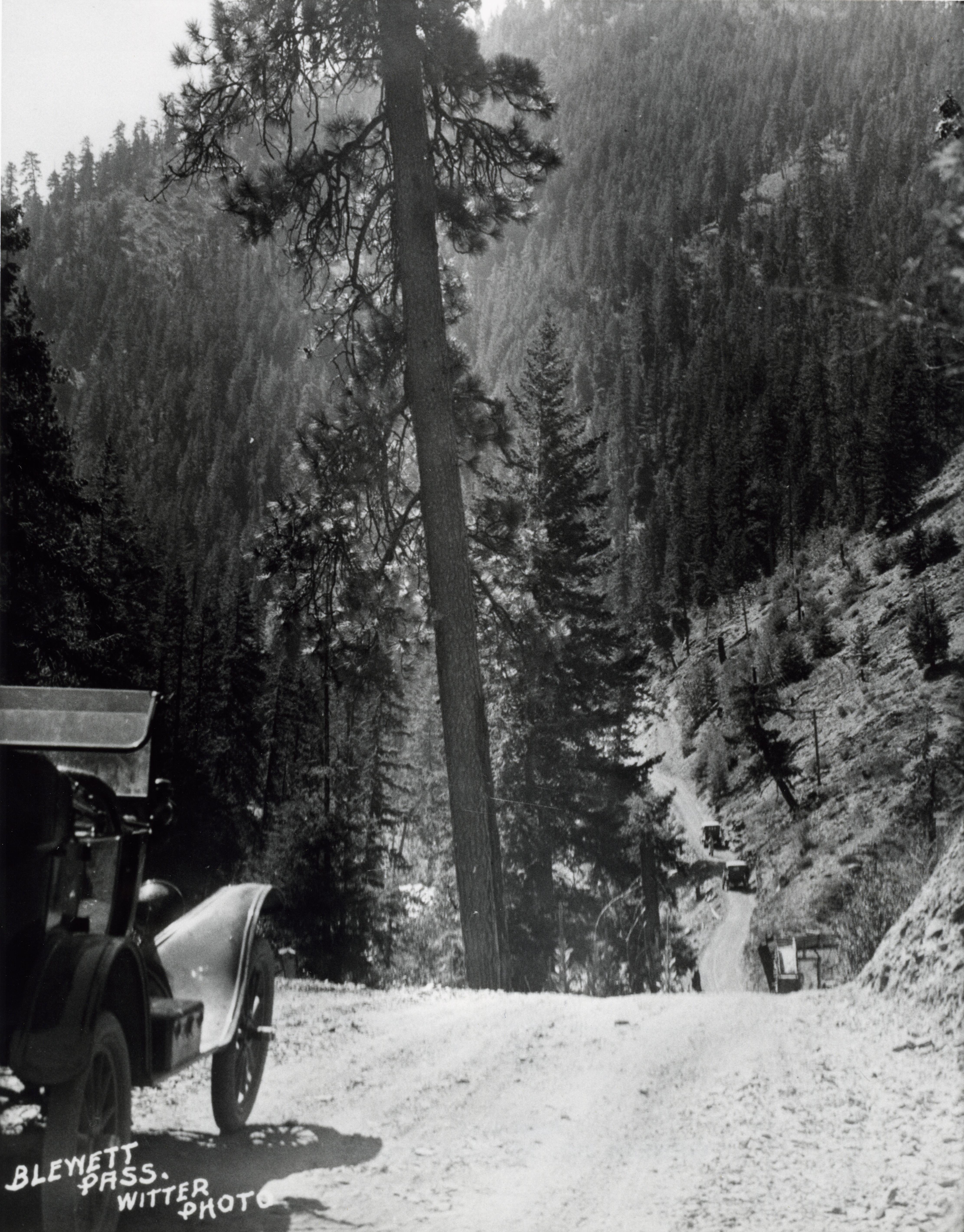
This 1920 scene is at the top of Blewett pass looking southbound at the 25% steep grade. |
![]()
©2014 - 2020 sunset-hwy.com
All Rights Reserved