The Historic Yellowstone Trail
in Montana
The Historic Yellowstone Trail
in Montana
History of Pipestone Pass
By Curt Cunningham
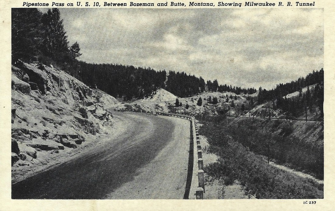
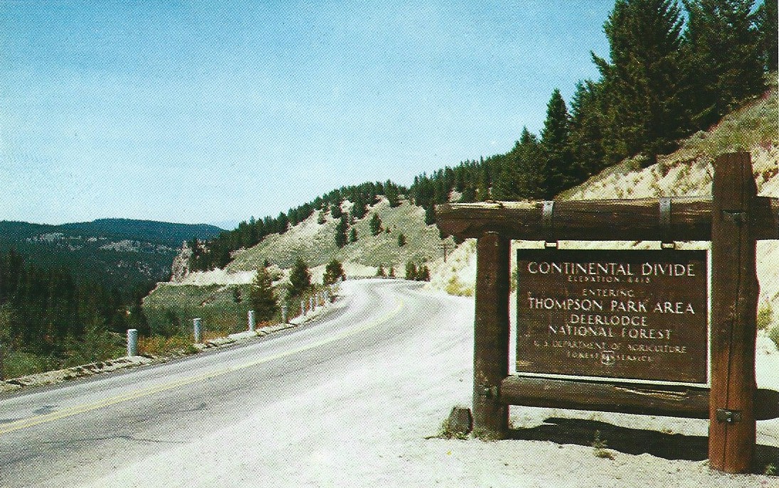
Pipestone Pass is located in the Rocky Mountains of Montana on the Continental Divide in Silver Bow County 10 miles south of Butte. The summit is at a height of 6,347 ft and the Yellowstone Trail crosses over this pass while on its way to the Pacific Ocean.
Pipestone is a hard reddish stone which was quarried by Indians to make prayer pipes, which were more commonly known by non-Indians as the peace pipe. The quarry where the stone was mined is located in Minnesota 39 miles NW of Sioux Falls, SD. The Indians who lived west of the Continental Divide crossed over at Pipestone Pass while on their way to the quarry. This is most likely how the pass got its name.
The route was nothing more than a one-horse trail, tracked only by the shod foot of man and beast. Early travelers knew the trail as the travel route of Indian, trapper and prospector. Before the Indian, big game elected this course as the mountain passageway offering the least resistance to progress.
Gradually the beaten track through the wilderness widened into a wagon road, which scarcely deserved that description until 1866 when Nelson M. Parsons built a sort of roadway over the hill. This road then became known as Eighteen Mile hill. It received that name because the hill was 18 miles from the stage depot near Silver Bow.
The primitive road was purchased from Parsons a few years later by Judge Andrew J. Davis (1819-1890) who is reputed to have been Montana’s first millionaire. He then began to charge tolls on his newly acquired road. The tollhouse was located on the east side of the pass and was known as the Eighteen Mile.
In 1877 and 1878 Deer Lodge county, (Silver Bow County was not established until 1881) under the direction of William Owsley, road supervisor, built a free road known as the Hill road, on the other side of the creek from Davis’ toll road. Judge Davis was then forced to stop charging travelers for the privilege of using his highway. William Owsley is credited as being the founder of Butte.
The hill was not as long as was commonly believed, and the misnomer of Eighteen Mile hill, given it in the early days, while Butte was in its infancy, was attributed to the habits of certain distinguished gentlemen of the city who in their youth wanted to have a strong drink and a good time.
The Eighteen Mile hill, many miles short of that length, came by its name not only because of the tollhouse and hill, but also a half-way house established in the mid 1870’s and was located 18 miles from that early stage depot. The Eighteen Mile Roadhouse as it was known was operated by Wes McCall and was frequented by Butte businessmen who occasionally, even in those days, styled themselves “tired businessmen” and sought good company from business worry and care.
The name survived as a nemesis for tourists, but the roadhouse had gone the way of time-imposed decadence. Gone are the days of the roadhouse and tollhouse, of the traveling Indian, trapper and the prospector.
After the roadhouse closed its doors, the McCall’s made the old building their home. It is unknown when the roadhouse closed its doors though it was most likely in 1882.
In 1873 William Wesley McCall (1845-1933) married Celestia Grace Jordan (1854-1916) whose father Harrison Jordan ran a mercantile store at Alder Gulch and was an early pioneer of Montana. Two years later the McCall’s arrived in Butte and stayed there a short time before settling on the Eighteen Mile hill. McCall was a famous old fellow whose sons became prominent citizens of Whitehall.
In 1882 McCall became the postmaster of the newly established Grace Post office which was located at the McCall residence on the Eighteen Mile. The office most likely was named for Celestia “Grace” McCall. The post office closed in 1891 when the McCall’s moved the Whitehall. The office reopened in 1892 with Rose Trefry as its postmaster. Thomas McCall the son of William and Celeste took over the post office in 1898 and ran it until 1909.
In 1909 The Chicago, Milwaukee, St. Paul & Pacific Railroad (commonly known as the Milwaukee Road) completed its line between Chicago and Seattle. The railroad crossed over the divide at Pipestone and constructed a 2,290 ft. tunnel under the summit which remained in operation until 1980. Today, the old grade through the tunnel is a pedestrian and bicycle trail.
They also built a station about 2 miles south of the Grace post office which was then moved to this location. James Grant took over as the postmaster and it remained in operation until 1929 when the office closed up for good.
The Grace station was named for Grace Penfield, the wife of W. H. Penfield, maintenance engineer for the railroad. The Milwaukee Road honored their employees and other famous people by naming their stations after them.
The station and post office was located where Grace Road crossed over the tracks. Today, nothing remains.
The Old Davis Grade
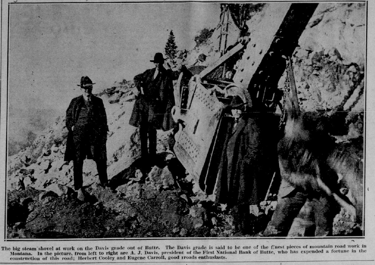
Judge Davis was the uncle of Andrew J. Davis (1863-1941) who in 1890 after his uncle’s death became the president of the First National Bank of Butte which the Judge had founded. In 1898 the United States Supreme Court affirmed the decision of the Montana court which gave Davis the bank as his share of the $10,000,000 estate left by his uncle. The bank was worth $1,000,000 at the time. The will had been contested by family members and became one of the most famous will contests in the history of civil jurisprudence in the country at the time.
Davis’ vision and money helped in the making of a new road over the pass a reality. In 1911 with a vision of a bigger Butte and a realization of the imperative need of good roads leading to the city, Davis tried unsuccessfully to get the county commissioners to build a new road over Pipestone Pass. Davis was determined to have this road and undertook at his own personal expense to make a real road out of the old trail.
In the name of good roads he spent about $10,000 of his own money on that road, which came to be known as the Davis grade.
The work done by him was virtually the last of the early road building methods when steam shovels, ditching machines and team-hauled graders were unheard of. Construction crews then took particular pride in being “hardboiled” and in having their camps designated as “roughneck camps.”
On the very first night that Davis’ crew settled in before beginning its road work, one of the members attempted a holdup and in the ensuing fracas one man was killed.
The entire crew of 60 was then taken into custody by the sheriff and then marched to town for lodging overnight in the county jail. After this interlude road construction commenced in earnest, and was done with shovel and pick, the only tools of modern invention at the time.
Recognition of Davis' generous contribution to good roads work was given, altogether unexpected by him, at a meeting of the Automobile club December 29, 1911. At that gathering, attended by 100 auto enthusiasts and presided over by Admiral Eugene Carroll, a large and expensive loving cup was presented to Davis as a token for his efforts for good roads.
On the cup, a possession highly prized by Davis, was the following inscription; “Presented to Andrew J. Davis by his automobile friends as a slight recognition of his efforts for good roads, Butte, Montana, December 29, 1911. At this meeting Davis was elected president of the club and from that time on he acted as a prod whenever signs of road improvement showed signs of slacking.
In 1915 when the Yellowstone Trail reached Seattle, the route over Pipestone Pass used the old Davis grade. It was very dangerous for those early autos and there were a few who accidentally drove off the edge and fell to their demise a thousand feet below.
In the spring of 1919 the Silver Bow county commissioners took a ride over Eighteen Mile hill and reiterated their earlier statements a week prior that they would install railings composed of heavy timbers at a height of 18 inches above the highway at all dangerous curves.This, they said would prevent autos from going off the grade. Whether nets would be installed on the side hills to catch the bodies of the occupants whose cars are stopped suddenly by the railings, was not mentioned.
On the eastern side of the pass traveling eastward the Yellowstone Trail followed the old wagon road and it veered off modern Highway 2 at Cedar Hills Road which is at the border between Jefferson and Silver Bow counties. This intersection is close to the location where the tollhouse and roadhouse once stood. This place is called Nineteen Mile on the 1963 USGS Grace Quadrangle map. The old dirt road then ran south then eastward about 2 miles south of Highway 2 and traveled through Piedmont before reaching Whitehall, MT.
The New Davis Grade
In the middle of August 1921 a contract was awarded to the Heiselt Construction co. of Salt Lake City to construct a new road over Pipestone Pass. The cost of the grade under contract as a federal aid project was $73,000, divided equally between the federal and county governments.
The state was not very interested in constructing a new Davis grade over the pass and a strenuous fight ensued for it to become a reality. Civic and commercial organizations got into the melee, and the smoke of battle was raised over the sanctuary of the state highway commission at Helena. Agitation for improvement of the old Eighteen Mile hill was made so insistent that completion of the concrete highway to Anaconda was temporarily suspended and authorization was given to use the unspent money of a road bond issue for construction of the new Davis grade.
The new highway over Pipestone Pass was completed in 1922 and instead of the feeling of sliding off the roof of a tall building while descending on the old wagon road; travelers could “shimmy” right along without fear of being dumped on their heads into a canyon a thousand feet below.
At its steepest point the new road does not exceed a 5% grade, compared with a 16% slant at one place in the old road. Hundreds began to travel over the new route of the Yellowstone Trail via the Davis grade each year, which gave a great boost in tourist business for Butte. Sunday drives from Butte over the grade would no longer be at risk of life and limb.
The new Davis grade quieted the terror of the tourists in approaching the Copper city and also the condemnation of other ambitious cities whose warnings had been; “go the other way to be safe.” Instead of a sensation such as might be expected in shooting the chutes of an amusement ride, the autoist now has only a gentle glide in dropping into Butte from the mountain tops to the east. The new road made safe and comfortable scenic trips from the city and also made the hauling by trucks from the ranch country and beyond an easy matter.
The Vigilante trail, which joined with the Yellowstone trail 22 miles from Butte, became one of the most heavily traveled tourist routes to Yellowstone Park, and the Davis grade was a perfect connecting link. The new highway over Pipestone continued to use the old wagon road down Cedar hill on the eastern side of the pass until 1931 when the Butte-Whitehall cutoff was completed between Cedar Hills Road and Whitehall.
In 1921 at a meeting of the Western Montana Yellowstone Trail association held in Butte it was unanimously resolved that the new road be called the Davis grade. The county commissioners were then petitioned to give it that name. This was out of further respect for Andrew Davis and for his invaluable work. Also it counteracted the prevailing impression, so readily played upon by other cities that discouraged travel in that direction, that the road east from Butte lead endlessly upward for 18 long, tedious and car-racking miles.
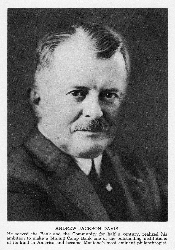
Andrew Jackson Davis
Photo courtesy Butte Historical society
1921 Construction of the new Davis Grade
Maps of the Route
Photos
![]()
©2014 - 2022 sunset-hwy.com
All Rights Reserved